 TemperateReefBase Geonetwork Catalogue
environment
Type of resources
Topics
Keywords
Contact for the resource
Provided by
Years
-
Temperature loggers have been deployed at a range of sites statewide in waters ranging between 6 and 22m depth. From 2012, 29 sites around Tasmania are being monitored. This record shows data collected from 2004 up to March 2025. Data is still being collected (July 2025) and will be added to this collection as it becomes available.
-
These data describe quantitative exposure indices generated using cartographic fetch methods on a 0.01 degree grid across temperate Australia (South Australia, Victoria and Tasmania). Two indices are reported: openness and bathymetry-altered fetch. Openness is a measure of the distance of a site to the nearest coastline in all directions and describes potential exposure to locally generated seas and undefined swell. Bathymetry-altered fetch attempts to account for the attenuation of wave energy as waves move into shallow waters and encounter friction with the seafloor.
-
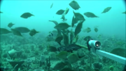
The Flinders CMR survey was a pilot study undertaken in August 2012 as part of the National Marine Biodiversity Hub's National monitoring, evaluation and reporting theme. The aim of this theme is to develop a bluepint for the sustained monitoring of the South-east Commonwealth Marine Reserve Network. The particular aims of the survey were twofold; 1) to contribute to an inventory of demersal and epibenthic conservation values in the reserve and 2) to test methodologies and deployment strategies in order to inform future survey design efforts. Several gear types were deployed; including multibeam sonar, shallow-water (less than 150m) Baited Remote Underwater Video (BRUVs), deep- water BRUVs, towed video and digital stereo stills. This resource contains the shallow-water BRUV footage captured on the FLinders CMR shelf (less than 150 m). Stereo BRUV's were deployed using a probabalistic and spatially-balanced survey design called Generalized Random Tessellation Stratified (GRTS). Habitats were identified in a previous multibeam survey and consisted of 'mixed reef' (containing patchy reef) and sand. Mixed reef habitat was targeted in this survey (9 GRTS mixed reef sites versus 3 sand sites). A total of 60 stereo BRUVs were deployed. Data contained here represents footage collected using these drops and the associated scored data (abundance (MaxN) and lengths).
-
Data from multibeam echosounder surveys taken as part of the Ningaloo Outlook project were classified into various seafloor cover types according to their hardness, rugosity and depth. The classifications were validated with towed video ground truth where it was available. This dataset describes two AOIs which are explicitly part of the Ningaloo Outlook Deep Reefs project. Substratum classifications were applied using multibeam backscatter angular response curves along with rugosity as input to a maximum likelihood classifier. See original metadata record(s) and associated attached documents for accuracy estimates, alternate classification techniques, and additional surveyed areas. https://doi.org/10.25919/kssa-5b46 https://doi.org/10.25919/kttc-x397 https://doi.org/10.25919/8m65-7k26
-
The SeaMap Tasmania project undertook mapping of seafloor habitats across the nearshore Tasmanian coastline (0-40 m) - the first state to compile a statewide asssimilated benthic habitat dataset. This initiative comprised of collating aerial photography (from archives), acoustic mapping, and conducting underwater video surveys and field-based visual observations. From this, 1:25,0000 scale habitat maps were created for shallow coastal water to within 1.5 km of the coastline (or 40m depth, which ever was arrived at first). Depth information was collected via acoustic methods and used to discriminate seafloor habitat type, in combination with scanned aerial photographs and towed video transects providing ground-truthing information. See 'Lineage' section of this record for full methodology and data dictionary. This data is also available via the Seamap Australia National Benthic Habitat Layer - a nationally consolidated benthic habitat map. https://metadata.imas.utas.edu.au/geonetwork/srv/eng/catalog.search#/metadata/4739e4b0-4dba-4ec5-b658-02c09f27ab9a
-
The SeaMap Tasmania project undertook mapping of seafloor habitats across the nearshore Tasmanian coastline (0-40 m) - the first state to compile a statewide asssimilated benthic habitat dataset. This initiative comprised of collating aerial photography (from archives), acoustic mapping, and conducting underwater video surveys and field-based visual observations. From this, 1:25,0000 scale habitat maps were created for shallow coastal water to within 1.5 km of the coastline (or 40 m depth, which ever was arrived at first). This record provided access to the raw video and associated annotations from video transects, which were subsequently used as validation (ground-truthing) for habitat mapping. A submersible digital video camera was deployed at selected locations around the Tasmanian coastline. These samples were used to verify the aerial photography and echo sounder substrate classification and obtain more detailed information on biological assemblages. Transects were undertaken from the LWM (Low water mark) to 80 metres in depth or 1.5 kms from shore. Positional information was recorded for each video drop as a series of DGPS coordinates and also as a direct overlay of the DGPS output (position, date and time) onto the video.